Unlock the Editor’s Digest for free
Roula Khalaf, Editor of the FT, selects her favourite stories in this weekly newsletter.
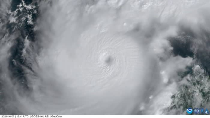
Hurricane Milton strengthened to a category five storm as it moved across the Gulf of Mexico on Monday, with US agencies warning of a possible life-threatening storm surge on the west coast of Florida and northern coast of the Yucatán Peninsula in Mexico.
The US National Hurricane Center upgraded the storm to the highest level on the Saffir-Simpson wind scale on late Monday morning, saying its wind speed was as high as 175 miles per hour.
Milton is due to make landfall in Florida on Wednesday, and is expected to bring heavy rainfall and storm surges as high as 12 feet to the southern state, hitting areas still recovering from hurricanes Helene and Debby.
Hurricane Helene, a category four storm, caused flooding and mudslides across several southern US states less than two weeks ago, killing more than 225 people.
President Joe Biden declared a state of emergency in Florida late on Monday morning in advance of the hurricane’s arrival. Milton could cause the largest number of evacuations since Hurricane Irma in 2017, in which 6.7mn residents were forced to relocate, according to global risk advisory firm Guy Carpenter.
The speed and intensity of this year’s hurricanes have led scientists to raise the alarm on the frequency of “compound events”, or dangerous weather episodes that occur at the same time or in short succession, making it more difficult for communities to prepare and recover from natural disasters.
Climate change is increasing the frequency of compound events, according to the latest US government National Climate Assessment.
Milton moved from being declared a hurricane on Sunday afternoon to a category five storm by Monday morning. Its wind speed accelerated faster than all but two previously recorded storms, increasing by more than 90 miles per hour in less than 24 hours, the National Hurricane Center said.
“I am stunned by how quickly this storm has intensified,” said Rachel Cleetus, policy director for climate and energy at the Union of Concerned Scientists.
“This is the unmistakable fingerprints of climate change that we are seeing here,” she added. As storms intensify more quickly and with less warning, the risk of serious harm and casualty increases, Cleetus said. “People have very little time to react to how strong a hurricane is going to be, and the scale of the devastation.”
For parts of Florida still recovering from Helene, “people are still reeling and resources are very stretched. That is going to make the harm worse”, she warned.
Federal assistance for Hurricane Helene had already exceeded $210mn, according to the White House, with almost $90mn of that bound for Florida.
A number of events have been cancelled as officials prepare for Milton’s arrival. The Donald Trump-JD Vance Republican presidential campaign postponed an event for Latino voters to be held in Miami on Tuesday because of the storm. “Our thoughts and prayers are with those in the path of Hurricane Milton,” the campaign said in a statement.
In an emergency briefing on Monday afternoon, Ken Graham, director of the National Weather Service, warned that some parts of Florida could receive as much as 15 inches of rain.
He also warned the public that the area affected by the storm’s intense wind was expected to expand when it makes landfall.
“To everyone in the path of Milton, the time to prepare is right now,” said Karine Jean-Pierre, the White House press secretary.
Additional reporting by Steff Chávez in Washington
Climate Capital
Where climate change meets business, markets and politics. Explore the FT’s coverage here.
Are you curious about the FT’s environmental sustainability commitments? Find out more about our science-based targets here


